Swansea's standalone roadside PM10 dust monitoring stations
If you are requesting data (in any format i.e. csv or pdf) please ensure that info.swansea.airqualitydata.com is added to your email systems "whitelist". If not, you may find that the emails are either not delivered or placed in your "junk" or "spam" folders.
There are currently five"standalone" PM10 dust monitoring stations that are providing data for swansea.airqualitydata.com.
Please note that all data is displayed as Greenwich Mean Time (GMT) and may therefore appear to be 2 hours "old" during the summer months. Also, please note that should the last date/time update show for example " Last updated: GMT 26 Jan 2010 09:00" this means the data displayed is for the period 09:00 to 10:00. The next update will reflect the period 10:00 to 11:00 etc etc
These monitoring stations are located around some of the more busy junctions within Swansea. The monitoring is intended to provide a provisional / screening assessment as the monitors do not comply or show equivalence with reference gravimetric standard.
|
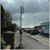
Monitoring station: Carmarthen Road |
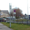
Monitoring station: Gower Road |
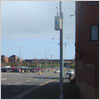
Monitoring station: Port Tennant Road |
 |
 |
 |
|
Fforestfach Situated at the Cross Road junction of Carmarthen Road with Ravenhill Road and Station Road |
Sketty Located in footway in front of petrol station and within 2m of heavily congested road. Residential properties close to monitoring site |
Port Tennant Sited at the new junction between the SA1 development, Fabian way and Port Tennant road. Analyser is approx 5m from front façade of terraced properties |
|
Monitoring station: Uplands Crsecent |
Monitoring station: Westway |
 |
 |
|
Uplands Located on footway of heavily trafficked Uplands Crescent. Analyser approx 8m from front façade of properties |
City Centre Located on footway in front of block of OAP |